Earthquake & Tsunami Warnings
to your mobile phone
The #1 Quake Alert service.
Turn your phone into a Quake Alert Device. Protect yourself & your family from Earthquake and Tsunami hazards. Get Alerts by SMS, Voice Call & Email.
Be the first to know. Easy setup, takes 1 minute.
| Get Facebook alerts: | |
| Get Twitter alerts: | Follow @SMS_Tsunami |

Be the first to know
Our system monitors seismic activity in real time and sends an alert notification to endangered users as soon as a significant earthquake strikes nearby their location (or is going to affect that location from a distance - ie. tsunami).

For you and your family
Protect yourself and your family from quake hazards. Alerts are sent to up to 5 people in the form of SMS, Voice Call, Email so that you are all simultaneously informed about possible threats. Stay protected, anywhere, anytime.

Global Seismic Activity
Always good to prepare for an earthquake
Earthquake Warnings are a Game Changer
Stay protected, anytime, anywhere
Unleashing Worldwide
We monitor earthquakes & tsunamis across the world
SMS-Tsunami-Warning.com is a web-based Earthquake Information System sourced from international seismic scientific centers that serves also as Tsunami Warning System.
Our website monitors global earthquake activity in real time and delivers vital information (quake location, magnitude, threat level, etc.) to endangered people when they need it the most. Although it's NOT possible to predict the time and the location of an Earthquake, it's crucial to handle this information in the quickest time possible, especially when powerful earthquakes strike in the ocean. Our website instantly alerts registered members by sending them a earthquake alerts by Email, SMS and Voice Call to their cell phone. Sign up for free now!
| Time | Location | MAG |
|---|---|---|
| 05-Jul-2025 @ 19:47 UTC | southeast of the Loyalty Islands | 5.3 |
| 05-Jul-2025 @ 19:42 UTC | Sabang, Indonesia (52km NNW) | 5.5 |
| 05-Jul-2025 @ 18:30 UTC | Waingapu, Indonesia (47km WNW) | 4.7 |
| 05-Jul-2025 @ 17:58 UTC | Saipan, Northern Mariana Islands (113km E) | 4.8 |
| 05-Jul-2025 @ 16:57 UTC | Tatsugō, Japan (93km NNW) | 4.6 |
- Previous
- Next
| Time | Location | MAG |
|---|---|---|
| 02-May-2025 @ 12:58 UTC | 2025 Drake Passage Earthquake | 7.4 |
| 29-Apr-2025 @ 14:53 UTC | Macquarie Island region | 6.8 |
| 04-Apr-2025 @ 20:04 UTC | Kimbe, Papua New Guinea (181km ESE) | 6.9 |
| 03-Apr-2025 @ 14:09 UTC | Reykjanes Ridge | 6.9 |
| 30-Mar-2025 @ 12:18 UTC | Pangai, Tonga (73km SE) | 7.0 |
- Previous
- Next
| Time | Region | Source |
|---|---|---|
| 05-Jul-2025 @ 18:20 UTC | Homer, Alaska (72km NW) | NTWC |
| 28-Jun-2025 @ 08:44 UTC | In the Scotia Sea, Southeast of South America | NTWC |
| 13-Jun-2025 @ 19:21 UTC | Iliamna, Alaska (89km NE) | NTWC |
| 06-Jun-2025 @ 17:22 UTC | Off the Coast of Northern Chile | NTWC |
| 26-May-2025 @ 08:42 UTC | Eureka, California (72km SW) | NTWC |
- Previous
- Next
Earthquake Alerts & Tsunami Warnings
Turn your mobile phone into an Early Warning System. Our service is essential for people living in coastal areas and for international travelers visiting seismic regions. Stay protected and enjoy peace of mind wherever, whenever. Signup to a Premium account to receive SMS and Voice Call alerts to your phone or signup for free to get Email alerts.
How does it work?
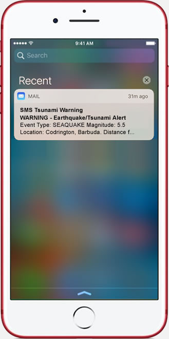
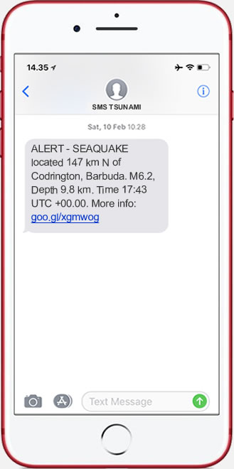
Should a violent seismic event happen, our members receive a warning message within 60 seconds from the moment the main shock is reported. Messages are solely delivered to members whose location is considered at risk by our algorithm. Warnings are sent to users on an individual basis (1-to-1 communication) in the form of SMS Text Message and Email. Members receive warnings onto their cell phones, smart phones and / or other electronic device capable of receiving SMS or email like iPads, Laptops, Desktop computers, etc. The warning message contains vital information such as earthquake type, magnitude, location, time and threat level. Our system allows subscribers to monitor simultaneously up to 5 locations worldwide and receive Warning Notifications on up to 5 email accounts and 5 mobile phones so that everybody in their family is alerted at the same time if any danger occurs. The system also allows users to change their location when they travel to coastal areas for leisure or business.
Who is going to ring the bell?
SMS-Tsunami-Warning.com operates 24 hours a day, 7 days a week, 365 days a year in every country.We deliver the message even though our members live far away from traditional Tsunami Warning Systems like sirens by the beach. Our website alerts people when they need it most based on their current location: we wake you up at night, or we reach you while you drive to work in the morning or whenever else you are not connected to media like TV or Radio. A Tsunami can occur from minutes to several hours after an Earthquake strikes, anywhere in the world. In this scenario, time is essential. Early warning is a requirement to limit disaster.The SMS Tsunami Warning System send you an alert straight to your cell phone and, as long as you get GSM signal and your phone is switched on, your phone will receive a warning message in a timely manner.
10 Reasons for subscribing!
1. SMS-Tsunami-Warning.com is the fastest SMS alerting system in the internet;
2. we successfully deliver SMS messages to 700+ carriers worldwide (check cellular carrier list);
3. our alert messages are clear and easy to understand;
4. we deliver warnings to up to 5 phone numbers per account, so your loved ones are alerted as well;
5. we are there for you when you sleep or are not in front of a TV;
6. tsunamis and earthquakes may happen anywhere on earth;
7. with a Premium membership, you make a donation to a NGO of your choice;
8. we service our members with an outstanding customer support available 24x7;
9. our Premium memberships are backed by a 30-day Money Back guarantee;
10. we let you update your current location and phone number so we keep an eye on you even when you travel.
Be part of our community and join the best! Stay safe with SMS-Tsunami-Warning.com, whenever, wherever.
How important is it to know?
For the cost of a small one-time fee that is partially donated to a NGO of your choice, SMS-Tsunami-Warning.com monitors the entire globe for you and, should a seismic event affect your region, it delivers an early warning at no further cost.If you consider that your life, your family, your friends and your property are important to you, then think of the benefits of becoming a member and being alerted about an incoming disaster, any time of the day and night. Minutes can save lives.If and where an impending disaster is imminent, Government and Local Authorities announcements may take too long, due to the statutory requirements and complicated procedures that go with it. You can be the first to know; time is everything to do the right action!
Who needs an Early Warning System?
This warning system is essential for coastal residents, tourists, business travelers, organizations and local businesses (hotels, restaurants, resorts, etc.). SMS Tsunami Warning offers you peace of mind as your mobile phone turns into a real-time Tsunami Warning System.
Resources
This website provides useful information on Earthquakes and Tsunamis. Its resources are aimed at raising Earthquake awareness and preparedness. Tsunamis are more frequent than what the public generally thinks. After the devastating tsunami that followed the 8.9 earthquake in Japan on March 2011, Indonesia, Thailand, Hawaii, the Pacific Islands, Australia, New Zealand, Chile and some other countries and are rated as the most likely places to be affected by the next Tsunami. Mainland US may be at risk too in consideration of the energy accumulated along the San Andreas fault in California and the exposure of the East Coast to a possible tsunami coming from the Canary Islands, off the coast of Morocco.
Awareness and understanding of these natural disasters are crucial for making the right decisions if ever needed.
Feel free to use our resources for personal use and study. If you intend to publish our content (texts, images, etc) on other websites or media, please let us know beforehand. Our content is protected by copyright but we are eager to share it with our trusted visitors. Just drop us an email to tell us how you would like to use the material.
Starting from an introduction to the features of Tsunamis, discover the Shoaling Process, the Run up and Inundation and the Drawback effect. Find out more about the Deadliest tsunamis in recent history supported by Tsunami videos and photos. As most of Tsunamis are caused by earthquakes, we provide as well a useful set of information about the structure of the Earth, P waves and S waves, Tectonic plates, Fault lines, Intra & Inner plates seismic events, Earthquake measurement techniques including the Richter Scale and much more!
The world’s leading internet-based service provider